
Keyword
Earth Science | Oceans
12 record(s)
Type of resources
Topics
Keywords
Contact for the resource
Provided by
Formats
Update frequencies
Status
draft
-
This data contains summaries of Victorian Fisheries Authority logbook data on effort distribution for VIC commercial fisheries in state marine and estuarine waters. The logbook data has been recorded and submitted to Victorian Fisheries Authority by commercial fishers. The data are aggregated to produce summaries of total effort by gear type (summarised across fishery), over 5 year periods and at a 0.1 degree resolution where 5 boats or more operate. All effort information has been removed for areas where less than 5 boats operate and these areas are mapped to a 1 degree resolution. The 5 year period (2011-2015) corresponds to State of Environment (SoE) Reporting, required under the EPBC Act 1999. Each map layer is labelled by the years aggregated (“2015” for 2011-2015) and the gear type (“HG” = Hand Gathering). The gear codes and aggregated fisheries and the shape file field descriptions are listed below. Field descriptions for shapefiles and effort units: Areacode Areasqm GRidSet_ID: Extract: extract date Source: VIC VFA Method: Gear type Period: Time Period Hours: Number of Hours of Effort CSQ: C-Squares code. 1 degree and 0.1 degree grids used Total Effort for each gear type Fishery and Gear Aggregations: GEAR_GROUP GEARS HL: Hand line, LLDL: longline dropline, MN: Mesh Net, Purse Seine Seine Net Trap Pot: (Trap, Pot, DropNet, HoopNet), TW_DS: (Trawl, Danish Seine). RL _Trap Pot: Rock lobster Trap Pot
-
This is the GHHP Biogeochemistry (BGC) and Sediments model data. It is based on the eReefs GHHP Hydrodynamic SHOC model data for physical properties plus a sediment transport model for predicting the fate of suspended fine sediments and a biogeochemical model for water column and benthic production, water quality and nutrient cycling. It includes a spectrally resolved light model and is forced by a wave model to calculate resuspension rates of particulate matter
-

SUPERSEDED: This dataset has been superseeded by GBR4_H2p0_B2p0_Chyd_Dcrt(2010-12 to 2016-10) and then by GBR4_H2p0_B3p1_Cq3b_Dhnd (2010-04 to 2019-04) and it was removed from the NCI fx3 project and THREDDS server in April 2024. An archive copy has been retained by the custodians, and access can be arranged on request. This is the eReefs GBR 4 km resolution Biogeochemistry (BGC) and Sediments model data version 926. It is based on the eReefs GBR 4 km Hydrodynamic SHOC model data for physical properties plus a sediment transport model for predicting the fate of suspended fine sediments and a biogeochemical model for water column and benthic production, water quality and nutrient cycling. It includes a spectrally resolved light model and is forced by a wave model to calculate resuspension rates of particulate matter
-
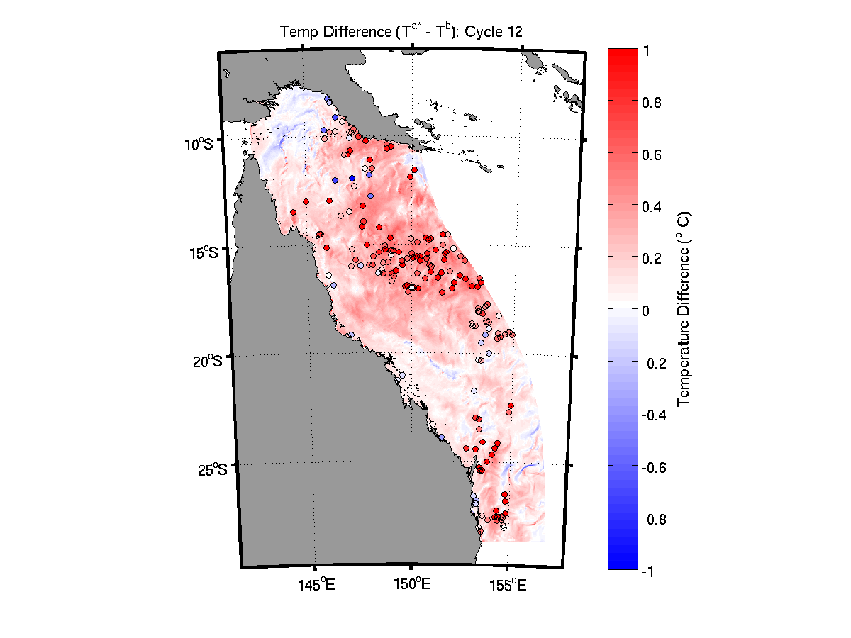
**This sample dataset was decomissioned in May 2022, and is no longer available via the NCI THREDDS server. Please contact the eReefs team if you need access to this data.** This is the eReefs GBR 4 km resolution Data Assimilating (DA) hydrodynamic SHOC model data. The Ensemble Optimal Interpolation (EnOI) system assimilaties a combination of temperature data from moorings (AIMS and GBROOS/IMOS), gliders (CSIRO and IMOS) and SST (GHRSST L3S from IMOS). This product is the first version of a reanalysis undertaken for the GBR4 grid. The DS system is run with a cycle length of 2 days, and assimilates temperature data that fall within a 6 hour window either side of the analysis time. The mean forecast error ranges from 0.4 degrees C in the "dry" season to 0.7 degrees C in the "wet" season
-

**This sample dataset was decomissioned in May 2022, and is no longer available via the NCI THREDDS server. Please contact the eReefs team if you need access to this data.** This is the eReefs GBR 4 km resolution complete hydrodynamic Sparse Hydrodynamic Ocean Code (SHOC) model data v1.85. It is comprised of ALL the tracers that are present in the SHOC model. The output format is non-CF compliant as it is a "standard" SHOC ALL file. It is based on the Arakawa-C grid with velocities on face centres that are oriented relative to the grid while all tracer values and surface elevation values are cell centred.
-
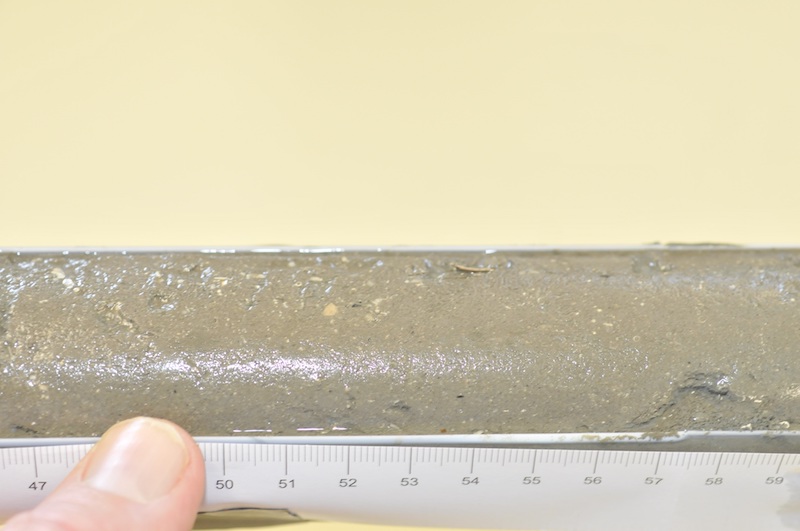
The remote Kimberley coast of north-western Australia is one of the few marine environments domains on earth largely unaffected by human use. However, the region is undergoing increasing economic importance as a destination for tourism and significant coastal developments associated with oil and gas exploration. The objective of the project was to reconstruct a timeline of inferred water quality changes from the sediment record for a selected set of sites in the Kimberley, Western Australia. The project made use of palaeoecological approaches to reconstruct a chronology of change over the last approximately 100 years using a series of biogeochemical proxies for phytoplankton composition and biomass, temperature and terrestrial influences. Where possible these were matched to historical land/water use, meteorological or hydrological observational records. The project examined sediment cores from three coastal locations, Koolama Bay (King George River), Cygnet Bay and Roebuck Bay. Each sampling location provided a contrast with which to evaluate changes over either a spatial or temporal gradient of human or natural influence. Sediment cores (up to 1.5 m) were obtained from each of these locations in the expectation that they would provide a time series for about the last 100 years. A set of parameters was measured along the core length (every 1-2 cm) for some or all cores depending on the particular focus for the location: 210Pb and 137Cs; 15N isotope; 13C isotope; Carbon/Nitrogen ratio; Sedimentation rate and grain size; Total Organic Carbon (TOC) and Total Nitrogen (TN); Biosilicate; Biomarkers; TEX86; long chain n-alkanes (C27+C29+C31); Elemental carbon (or black carbon). Rainfall data was obtained from the Australian Bureau of Meteorology website (www.bom.gov.au). Stream flow data was obtained from the Western Australian Department of Water website (www.water.wa.gov.au). Historical bushfire data was obtained from the Western Australian Department of Parks and Wildlife. The metadata record only relates to data generated as part of the sediment analysis.
-
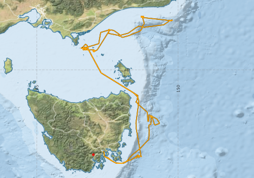
This record describes gravity data collected on RV Investigator voyage IN2019_V07, 'RAN Hydrographic and Maritime Heritage Surveys' which departed Hobart on the 11 April 2019 and returned to Hobart on the 23 April 2019. The gravity meter instrument is a MicroG Lacoste Air-Sea II. Data are stored in .ENV and .DAT data files at CSIRO. There are 13 files totalling 197 MB of raw data in this dataset. Wharf tie[s] were not undertaken. but static readings were obtained at the Start and End of the voyage alongside in Hobart. No processing has been conducted on this data. Additional information regarding this dataset is contained in the GSM data acquisition and processing report.
-
This record describes the Iron(II) data collected from the Marine National Facility RV Investigator voyage IN2016_V01 titled: "HEOBI: Heard Earth-Ocean-Biosphere Interactions." The voyage took place from Fremantle (WA) to Hobart (TAS) between January 7 and February 27, 2016. This dataset was produced as part of the project "Heard Earth-Ocean-Biosphere Interactions (HEOBI), GEOTRACES process study GIpr05." Samples were analysed using Flow Injection Analysis – Chemiluminescence (FIA-CL) method on-board during the voyage. Voyage, date, time, latitude, longitude, sampling site (TMR), bottle numbers and depths are included. The collected data were subsequently archived within the CSIRO Oceans and Atmosphere (O&A) Information and Data Centre (IDC) in Hobart. Additional information regarding this dataset may be contained in the Voyage Summary and the CTD Data Processing Report.
-

This record describes multibeam echosounder data collected on RV Investigator voyage IN2019_V07, 'RAN Hydrographic and Maritime Heritage Surveys' which departed Hobart on the 11 April 2019 and returned to Hobart on the 23 April 2019. The Kongsberg EM122 multibeam echosounder was used to acquire seafloor bathymetry, backscatter information [and watercolumn backscatter] along the Tasmanian East Coast/Tasman Sea. The EM122 provides a 1 degree by 1 degree angular resolution. The echosounder's nominal frequency is 12 kHz. Data are stored in *.all raw format for bathymetry and backscatter and *.wcd format for watercolumn backscatter at CSIRO. There are 102 files totalling 3.37 GB of raw data in this dataset. Sound velocity profiles were applied to this data during data acquisition. Bathymetry data contained in *.all format are corrected for motion and position. Tide corrections were not applied to the processed data. Processed data had outliers removed. Processed line data are available in *.gsf and ascii format, and processed bathymetry and backscatter grids in geotiff format. Additional information regarding this dataset, including information on processing streams, is contained in the GSM data acquisition and processing report. Additional data products may be available on request.
-
The Kimberley region is vast, remote and difficult and expensive to access and carry out field work in. Remote sensing technologies can provide cost effective methods to gather historical and baseline data at synoptic scales as well as near-real-time observations from metre to kilometre resolution. The Kimberley Node Project 1.4 focused on monitoring turbidity with reference to its impact on the water column and substrate light environment. The projects objectives were to analyse uncertainties of remotely sensed turbidity products by comparison of different algorithms and different resolution products with each other and with archived in situ data; and to analyse time series of remotely sensed turbidity data to provide first-stage pilot products that may be applicable for future use as marine management tools. In-situ water quality data was obtained from a number of cruises that occurred along the Kimberley coastline including Collier Bay; Walcott Inlet, Outer King Sound, Koolama Bay and Lesueur Islands, Van Diemen Gulf and the Pilbara Coast and used to validate remote sensing products. Data associated with this metadata record relates to in-situ water quality. MODIS satellite data obtained from IMOS has not been stored as part of this record, but can be accessed direct via IMOS (http://www.imos.org.au/).